Description
SKU (ISBN): 9789901980987
UPC: 646723000783
Binding: Other
Then And Now Bible Maps
Publisher: Rose Publishing

$14.99
Heavy Chart Paper
Additional Info
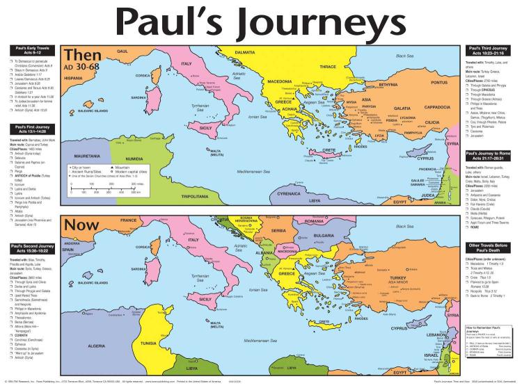
Follow Paul’s Travels with this laminated wall map.
Paul’s Journeys: Then and Now wall map compares a Bible map side-by-side with a modern-day map of the Roman Empire at the time of Paul. The clear, colorful map provides a simple way of enhancing many New Testament Bible stories, including Paul’s Journeys, Barnabas, Silas, the Road to Damascus, Peter, and the churches of Revelation. Available laminated or unlaminated.
Goes perfectly with the Life of the Apostle Paul pamphlet, which includes 200 fascinating facts about Paul: his youth, education, persecution of Christians, conversion to Christianity, missionary journeys, and teachings. (Product Code: 329X)
Topics include: Adriatic Sea, Aegean Sea, Antioch, Apostle Paul, Arabia, Asia, Bible map, Bible maps, Black Sea, Caesarea, Colossae, Colossae ruins, Constantine, Constantinople, Corinth, Egypt, Ephesus, first missionary journey, France, Galatia, Galilee, Israel, Jerusalem, Joppa, Jordan, Judea, Libya, Lycaonia, Lycia, Lystra, Macedonia, Malta, map, Marseille, Mediterranean Sea, Mount Olympus, Patmos, Paul, Paul the Apostle, Pauls journeys, Pergamum, Philadelphia, Philippi, Rome, Saul of Tarsus, then and now, Thessalonica, Thyatira, Turkey, Tyre, Tyrrhenian Sea
1 in stock
SKU (ISBN): 9789901980987
UPC: 646723000783
Binding: Other
Then And Now Bible Maps
Publisher: Rose Publishing

in stock within a week of online purchase

in stock within a week of online purchase

in stock within a week of online purchase
Reviews
There are no reviews yet.